Urbanie & Urbanus

Issue 2020 Nov
The Liveable City
Issue 4, P.33 - P.50
TOD, volumetric TOD, Destination, Public Space and Community Cohesion
Figures

Figure 1: Social cohesion radar and their dimensions (source: Stiftung, 2017)
.jpg)
Figure 2: Diagrammatic pathways of the relationship between BE and Social cohesion (source: Liu, et al., 2017)
_and_control_(Red)_(source_adaopted_from_Open_Street_Map,_2017).jpg)
Figure 3: MTR stations case study (Yellow) and control (Red) (source: adaopted from Open Street Map, 2017)

Figure 4: Compounded annualised rate of change, population rent_income ratio, income, rent over 2006, 2011, 2016
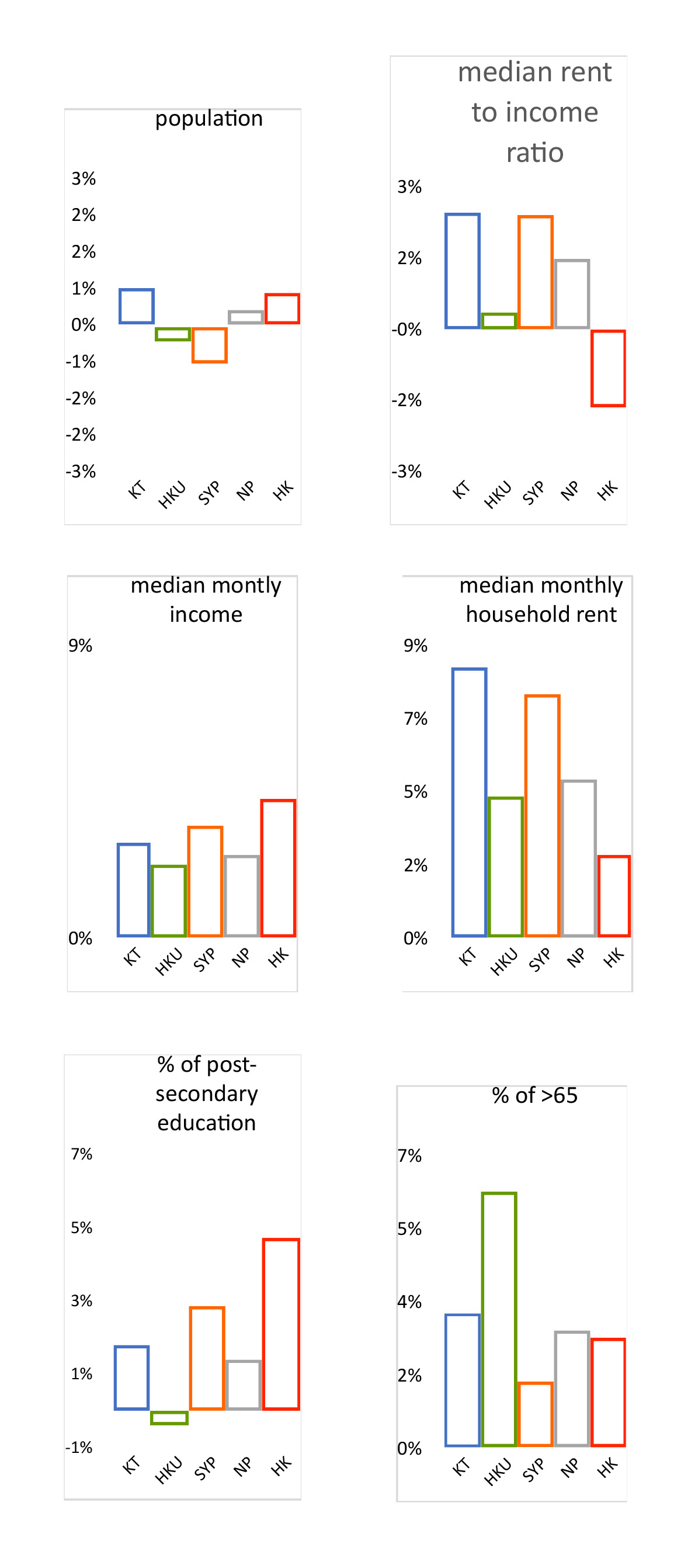
Figure 5: Compounded annualized rate of change

Figure 6: North Point - change in number and type of street premises 2009 & 2017/19 (source: Authors)
.jpg)
Figure 7: Kennedy Town - change in number and type of street premises 2009 & 2017/19 (source: : Authors)
.jpg)
Figure 8: HKU - change in number and type of street premises 2009 & 2017/19 (source: : Authors)
.jpg)
Figure 9: Sai Ying Pun - change in number and type of street premises 2009 & 2017/19 (source: : Authors)

Figure 10: KT, mapping of open and green space associated with MTR opening (source: Adapted from Open Map)
_(Bottom_Left).jpg)
Figure 11: KT, Smithfield Street, 2009, before MTR Station (Source: Google Street View) (Bottom Left)
_(Top_Right).jpg)
Figure 12: KT, Smithfield Street, 2017, after MTR Station (Source Google Street View) (Top Right)
.jpg)
Figure 13: KT, new public space, Smithfield, 2020 (Second Right)
.jpg)
Figure 14: KT, new public space, North Road, 2020 (Third Right)
Figure 15, KT, new seating outside new HK chain coffee shop with expansive waterfront view, New Praya. 2020
.jpg)
Figure 16: HKU, mapping of open and green space associated with the MTR opening (source: adapted from Open Map)
_HKU,_Belcher_2009_&_2017,_note_the_reduction_in_green_space_(source_google_street_view).jpg)
_HKU,_Belcher_2009_&_2017,_note_the_reduction_in_green_space_(source_google_street_view).jpg)
Figure 17: HKU, Belcher 2009 & 2017, note the reduction in green space (source: google street view)
_HKU_Hill_Rd_and_Whitty_St._small_open_and_green_space_were_added_(source_Authors).jpg)
_HKU_Hill_Rd_and_Whitty_St._small_open_and_green_space_were_added_(source_Authors).jpg)
Figure 18: HKU Hill Rd and Whitty St. small open and green space were added (source: Authors)

Figure 19 New open space outside the new swimming pool, off HKU Belcher MTR (source: Authors)
.jpg)
Figure 20: SYP, mapping of open and green space associated with the MTR opening (source:adapted from OpenMap)
.jpg)
Figure 21: SYP, Ki Ling Lane Children’s playground, between Des Voeux Rd West and Queen’s Rd West (source: Authors)
.jpg)
Figure 22: SYP, Sai Woo Lane Playground, and football field (source: Authors)
.jpg)
Figure 23: SYP, Queen’s Road West (source: Authors)
.jpg)
Figure 24: SYP, Centre Street Market (source: Authors)
.jpg)
Figure 25: SYP, Bonham Rd (source: Authors)

Table 1: BE factors metrics that related to social cohesion (Source: Mazumdar, et al., 2018)